Fleet tracking, asset intelligence, safety, cold-chain visibility, reporting, and integrations—shaped around your operation with Sapience implementation and analytics support.
More than a map: a management system for connected operations.
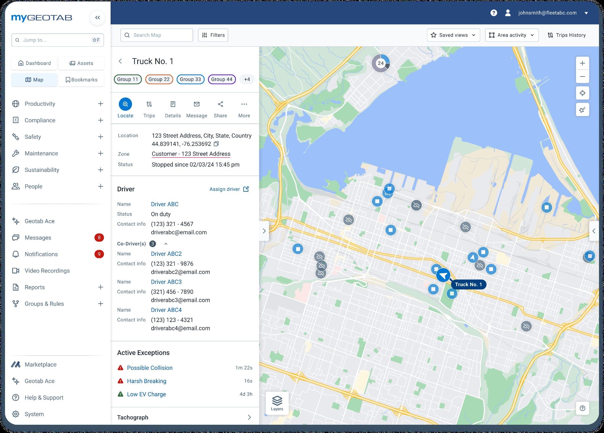
MyGeotab can bring vehicle, asset, camera, refrigeration, OEM, and third-party data into one extensible platform. The value comes from designing how that information is reviewed and used—not simply collecting more of it.
Annotated operating principle: collect only what supports a defined alert, report, workflow, or management decision.
01
Capture the right signals
Use suitable vehicle, asset, video, refrigeration, or third-party data for the operating requirement.
02
Bring the operation into view
MyGeotab gives managers one place to work with maps, trips, rules, alerts, reports, and connected data.
03
Route exceptions to people
Shape maintenance, safety, utilisation, cold-chain, and compliance signals into reviewable workflows.
04
Improve the management system
Connect reporting and integrations to the decisions, coaching, and operating rhythms that already exist.
Filter by the operating need, then compare visibility, benefit, installation, and next actions. Availability and compatibility are verified before a recommendation or quote.
Showing 7 Geotab solutions for All solutions.
Comparison of relevant Geotab products available for Australian fleet requirements.
Refrigerated transport operations that need compatible temperature and refrigeration-unit data visible with fleet activity.
Near-real-time temperature and refrigeration data where supported
Alerts and reporting in MyGeotab
Rugged option for demanding environments
Bring cold-chain operating signals into the fleet view so teams can identify exceptions and strengthen review and reporting workflows.
Refrigeration-unit model, harness, available data points, cable routing, environmental exposure, and installer scope must be confirmed vehicle by vehicle.
Compatibility varies by refrigeration unit and installation. Sapience confirms supported data and hardware before quotation.
Operations that need Geotab data connected to maintenance, ERP, CRM, BI, compliance, dispatch, or specialised partner solutions.
Marketplace partner solutions
SDK and API integration pathways
Custom dashboards, workflows, and data exchange
Reduce duplicated handling and connect fleet signals to the systems and decisions that sit beyond telematics.
Data ownership, API scope, security, identity, refresh frequency, system limits, and support responsibility should be agreed in the integration design.
This covers relevant pathways, not every Marketplace integration; individual products and licences are assessed against the requirement.
Powered vehicles and equipment that need a shared view of location, trips, utilisation, safety, maintenance, and engine data.
Visibility and data
Vehicle and trip visibility
Rules, alerts, reporting, and maintenance workflows
Vehicle and engine data where supported
Operational benefit
Bring fleet activity into one operating view so managers can find exceptions, compare performance, and act sooner.
Installation and availability
Device choice, harness, vehicle compatibility, installation method, and required data should be confirmed for each vehicle class. GO Rugged is intended for exposed or demanding installation environments; the suitable device is confirmed during solution design.
Fleets that want road and cabin context for serious safety events, together with in-cab feedback and coaching workflows.
Visibility and data
Forward and driver-facing video
AI-supported event detection and in-cab feedback
Event review inside the Geotab ecosystem
Operational benefit
Give safety teams video-backed context for priority events and a clearer basis for timely driver coaching.
Installation and availability
Camera placement, power, driver communication, privacy settings, retention, and the coaching process should be agreed before rollout. Australian product scope and configuration should be reconfirmed against the operating and privacy requirements of the fleet.
Fleets seeking road-facing video context without a driver-facing camera in the standard configuration.
Visibility and data
Forward-facing road video
AI-supported road-event context
Connected event review and fleet data
Operational benefit
Support incident review and road-risk coaching while using a camera configuration that may better fit some privacy policies.
Installation and availability
Road view, windscreen position, privacy policy, event rules, access, and retention should be documented before deployment. Use case and current Australian availability should be checked during the fleet review before selection.
Complex vehicle operations that need expanded camera coverage around the vehicle and more complete incident context.
Visibility and data
Multi-camera video coverage
Connected telematics and event context
Centralised review for complex safety scenarios
Operational benefit
Extend visibility beyond a single forward or cabin view for vehicles with blind spots or higher-risk operating environments.
Installation and availability
Camera layout, vehicle body type, cabling, power, storage, network conditions, and installation downtime require a vehicle-specific design. Geotab announced Australian availability from July 2026; scope and lead time should be revalidated before quotation.
Trailers, containers, equipment, and other assets that need location, movement, or utilisation visibility without relying on a powered vehicle.
Visibility and data
Asset location and movement visibility
Configurable reporting and alerts
One view alongside vehicle data in MyGeotab
Operational benefit
Reduce time spent locating assets and create a clearer view of asset movement, availability, and exceptions.
Installation and availability
Mounting position, environmental exposure, reporting frequency, expected battery life, and network coverage should match the asset use case. Hardware fit and reporting behaviour depend on the asset, environment, and operating profile.
Refrigerated transport operations that need compatible temperature and refrigeration-unit data visible with fleet activity.
Visibility and data
Near-real-time temperature and refrigeration data where supported
Alerts and reporting in MyGeotab
Rugged option for demanding environments
Operational benefit
Bring cold-chain operating signals into the fleet view so teams can identify exceptions and strengthen review and reporting workflows.
Installation and availability
Refrigeration-unit model, harness, available data points, cable routing, environmental exposure, and installer scope must be confirmed vehicle by vehicle. Compatibility varies by refrigeration unit and installation. Sapience confirms supported data and hardware before quotation.
Operations that need Geotab data connected to maintenance, ERP, CRM, BI, compliance, dispatch, or specialised partner solutions.
Visibility and data
Marketplace partner solutions
SDK and API integration pathways
Custom dashboards, workflows, and data exchange
Operational benefit
Reduce duplicated handling and connect fleet signals to the systems and decisions that sit beyond telematics.
Installation and availability
Data ownership, API scope, security, identity, refresh frequency, system limits, and support responsibility should be agreed in the integration design. This covers relevant pathways, not every Marketplace integration; individual products and licences are assessed against the requirement.
Review serious events with the road, telemetry, and coaching context together.
GO Focus options connect video context with fleet data. Sapience helps define the camera configuration, event rules, privacy approach, review process, and management reporting around it.
Camera and vehicle context
Compare road-only, road-and-driver, and multi-camera pathways against vehicle, safety, privacy, and installation requirements.
Connected event review
Use footage with event and vehicle data to support a consistent review, escalation, and driver-coaching workflow.
Fleet work grounded in operational decisions and usable evidence.
These existing public project notes show Sapience's fleet, modelling, and integration capability. They are not presented as Geotab deployments and no unsupported numerical results have been added.
01
Transport fuel and vehicle activity reconciliation
Operational workflow and analytics design
Problem
Fuel records were difficult to trust when usage behaviour and vehicle context did not line up neatly.
Sapience work
Sapience built a workflow that compared fuel activity with vehicle location and timing signals, separated likely matches from ambiguous cases, and flagged exceptions for review.
Outcome
The workflow reduced manual investigation and gave management a clearer, more defensible way to review unusual activity.
Systems integration and operational dashboard design
Problem
Operational data had to be handled manually between source systems and management reporting.
Sapience work
Sapience connected transport activity data into a dashboard workflow so vehicle activity and fatigue-related indicators could be reviewed without re-keying information.
Outcome
The work reduced duplicated entry and improved the speed and clarity of management review.
What Australian fleet teams usually need to establish before rollout.
01What does the Geotab platform cover?
Geotab combines the MyGeotab platform with vehicle, asset, video, cold-chain, and integration options. Depending on the selected hardware and data available from each vehicle, teams can work with location, trips, utilisation, safety events, maintenance signals, engine information, asset movement, video context, and refrigeration data. Rules, alerts, reports, dashboards, Marketplace solutions, and API pathways help turn those signals into operating workflows. Sapience starts by defining the management decision or process that needs to improve, then maps the appropriate Geotab capability rather than treating every fleet as the same hardware rollout.
02How do we choose the right Geotab products for our fleet?
Product selection starts with fleet composition, operating environment, desired visibility, risk priorities, existing systems, and the decisions managers need to make. A powered metro van, a rugged civil asset, a refrigerated trailer, and a complex heavy vehicle may need different devices, harnesses, cameras, data, and installation approaches. Sapience uses the Geotab Fleet Review to document those requirements, identify assumptions and compatibility checks, and compare a staged rollout with broader coverage. The result is a practical solution outline and next step, not an automatic recommendation to install every available product.
03What is the difference between GO Focus Plus, Road Only, and GO Focus Pro?
GO Focus Plus supports road and driver-facing video with AI-assisted event context and in-cab feedback. The Road Only configuration is intended for fleets that want forward-facing road context without a driver-facing camera in the standard setup. GO Focus Pro extends coverage through a multi-camera system for complex vehicles and operating environments that need visibility around more of the vehicle. The right choice depends on the risk being managed, vehicle design, privacy policy, coaching process, installation scope, and current Australian availability. Sapience confirms those requirements before recommending a camera configuration.
Installation depends on the vehicle or asset, selected device, harness, mounting position, environmental exposure, camera layout, refrigeration-unit compatibility, and required data. A sound rollout begins with a vehicle and asset register, compatibility review, agreed installation standard, pilot group, acceptance checks, and a plan for downtime and support. Sapience coordinates the solution design and confirms what must be validated with the hardware supplier or installer. For mixed fleets, installation should be scoped by vehicle class rather than assuming one kit and one procedure will suit the entire operation.
05Can Geotab connect with our existing business systems?
Yes. Geotab provides Marketplace solutions plus SDK and API pathways that can support connections to reporting, maintenance, dispatch, compliance, ERP, CRM, and other operational systems. The useful question is not simply whether a connection is technically possible, but which data should move, how often it should update, who owns it, and what workflow or decision it improves. Sapience can map the integration, shape the data model, build dashboards or workflow automation, and define monitoring and support responsibilities. Each integration is assessed individually for security, licensing, system limits, and ongoing maintenance.
06Can Geotab support refrigerated and cold-chain fleets?
Geotab cold-chain options can bring compatible refrigeration and temperature data into MyGeotab alongside vehicle activity. IOX Cold and IOX Cold Rugged can support near-real-time monitoring, reporting, and alerts where the refrigeration unit, harness, installation, and available data points are supported. Compatibility is not universal, so the refrigeration make and model, desired sensors or signals, cable route, environmental exposure, and installer scope must be checked vehicle by vehicle. Sapience has completed Geotab IOX Cold certification and uses that process to define a supportable scope before a quote or rollout is proposed.
07How should we handle driver privacy with telematics and cameras?
Driver privacy should be designed into the rollout, not added after installation. Fleets should define the operating purpose, data and footage collected, who can access it, retention settings, review triggers, coaching process, escalation path, and how drivers will be informed. Camera choice matters: a road-only configuration may suit a different policy from a road-and-driver-facing setup. Sapience can help translate the intended safety or operational outcome into documented requirements and access workflows, but your organisation should obtain its own workplace, privacy, and legal advice for the final policy and consultation process.
Sapience supports the work around the technology: discovery, fleet and asset scoping, solution comparison, rollout planning, reporting, dashboard design, workflow integration, management adoption, and ongoing improvement. The engagement can begin with a national Geotab Fleet Review or, for qualifying WA fleets, the more focused Fleet Cost and Compliance Benchmark. Sapience does not present every prior fleet analytics project as a Geotab deployment, and it does not invent savings claims. Recommendations are based on the documented operating problem, verified product information, compatibility checks, and the evidence available from your fleet and systems.